
 I Want To
Water Safety Alert
MNRF has issued a Flood Warning that flooding is imminent or occurring within specific watercourses and municipalities. MNR advises municipalities and residents to take immediate action to safeguard homes and property. Flooding could occur quickly and with little or no warning.
CVCA his issued a Flood Watch – downgrading the Flood Warning issued on April 15 – for all lakes and rivers within the watershed.
The Ministry of Natural Resources and Forestry – Bracebridge Minden Parry Sound District is advising area residents and visitors that a Watershed Conditions Statement - Flood Warning is in effect in the district until Wednesday, April 29, 2026.
The Crowe Valley Conservation Authority has downgraded the Flood Warning to a Flood Watch, effective immediately that will be updated on Thursday, April 30, 2026 or as conditions warrant.
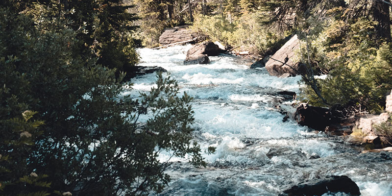
Washouts, damage, flooding possible
With precipitation and continued warm temperatures in the forecast, some areas may experience elevated water levels and flows. In some locations, this could approach levels observed in 2019 and may result in localized road washouts, infrastructure damage, and flooding.
Go to ontario.ca/page/floods for more information.
High lake and river levels
Residents and visitors should expect lake water levels to continue to rise and river flows to remain high throughout this week and into late next week.
Residents that have been affected by high water and flow conditions in the past should continue to take necessary action to protect/secure any vulnerable property in proximity to rivers and lakes and closely monitor developing conditions.
Lower-lying portions of known flood-prone areas may be impacted to various degrees as runoff from rainfall and melting snow enters watercourses.
No ice is safe ice
MNR advises residents to exercise extreme caution concerning ice conditions. No ice is safe ice. Some lakes within the area are still covered in ice. Increased water levels and precipitation may erode the ice and create floating ice hazards that could damage waterfront infrastructure. Anyone planning to venture onto the ice should check the ice conditions often, plan ahead, and be prepared for an emergency.
Exercise caution
MNR also advises extreme caution when using forest access roads for outdoor activities as many are seasonally inundated with water, prone to washouts, and may be impassible due to current water levels.
Higher than normal water flow conditions are occurring throughout the area due to recent rainfall and snowmelt. Slippery stream banks and fast flowing, cold water will create hazardous conditions around all water bodies. Residents are reminded to keep a close watch on weather conditions, regularly check for updated messages, exercise caution near fast-moving rivers and streams and maintain close supervision of children and pets.
Description of weather system
Generally dry and warm conditions are expected over the next seven days, which may limit
additional runoff.
The 7-day weather forecast is predicting daytime highs of 12°C to 17°C and overnight lows
between 1°C and 7°C with up to 10 mm of rainfall.
Description of current conditions
- River levels and flows within the district remain elevated and are expected to persist across most locations.
- Lake water levels in several areas are near or have exceeded the upper limits of the Normal Operating Zone (NOZ) and are now in the High-Water Zone.
- Remaining snowpack is limited and is expected to have minimal impact on runoff.
Contact Us
 Subscribe to this Page